It was on this flight in from Berlin to London that I first thought of using a GPS receiver as a tool to draw with.

Berlin to London
It was on this flight in from Berlin to London that I first thought of using a GPS receiver as a tool to draw with.
I had a Garmin eTrex that I was using to geographically organise my photographs and I was curious to see if it would work thought the window of aeroplane.
It did, and as we made the turns of the holding patterns I became enthralled with the size and beauty of the shapes being plotted on the screen of the device.
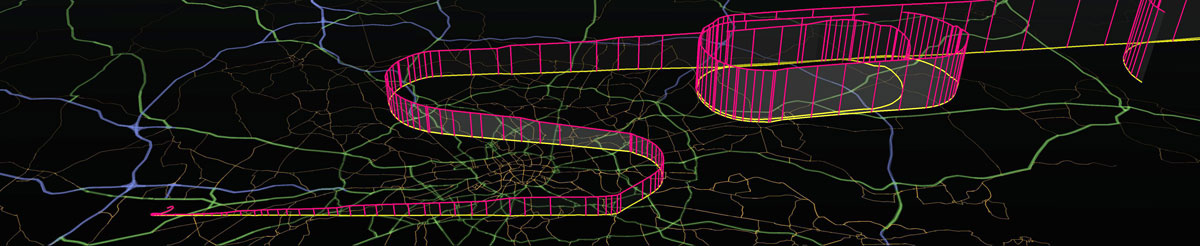
I had captured a digital contrail and had not seen anything like it before. And so began a project that has taken me to experiment with GPS drawing and sculpture and to map my everyday movements.
To mark the 10th anniversary of the flight I created some new images using Google Earth.

Location: (TXL) Tegel Airport, Berlin, Germany
to (LHR) Heathrow Airport, London, UK.
Date: 02/10/2000
Track Length: 1103 km
Altitude: 35000 ft.
Method: Airbus A320 jet
Credit: Jeremy Wood
To record to whole journey I wedged the receiver between my shoulder and the window.
The receiver lost reception a few times, significantly so during lunch and whilst performing the holding pattern manoeuvres near London Heathrow.
GPSograph_ Shockwave Viewer

The idea of GPS drawing came to me on this geodetic pencil with wings


Take-off from Berlin Tegel Airport

Looking towards London

Image rendered by Hugh Pryor with POV-Ray (Persistence of Vision Raytracer)


jeremy wood.