GPS Drawing [Gallery]
[Maps] [Info]
Wingsuit Skydive
Craig Poxon "So-called belly-to-earth skydivers fall at a rate of 120mph"
View from above:


"Whereas traditional skydiving involves mainly falling straight down,
adding ram-air wings to suits
enables skydivers to dramatically reduced their
vertical speed and increase the horizontal.
In the data I have reduced that to an average of 70 mph with horizontal speeds
in excess of that.
Although I am an amateur, more skilled people than myself have achieved much
better speeds."
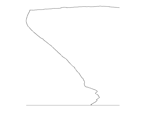
"There are three distinct aspects of the profile. The first is the long
straight line at approximately 13000ft. This is the aircraft 'running-in' over
the dropzone.
The second is a curving descending path in the opposite direction. This is my
freefall journey in the suit. The third is a more wiggly curve.
This is my journey after I have deployed my parachute to landing. You may see
a dog-leg in the early part of this section.
This is where my parachute is flying without input from me as I undo various
parts of the suit in order for me to take control.
Once I take control there is a change in course. The rest of the flight is me
enjoying myself and lining myself up to land on the dropzone."
Side view
GPSograph_ Shockwave Viewer
Location: Near Nottingham, UK. N52.88623
W0.89058 - N52.89009 W0.90650
Date: 28/10/2001
Time: 11:24:07 - 11:36:16
Altitude: 13354 ft - 93 ft
Method: Skydive with wingsuit and parachute
Credits: www.poxon.org/Craig/Skydive
gpsdrawing.com/gallery.html